


| History & heritage 05 May 2020 - Elliott Brown |
Did you know? |
Birmingham over the Centuries from the Romans to the City Council

Did you know? A Birmingham post going over the centuries of Birmingham history and pre-history. Not just covering what is now the City Centre but areas of Birmingham's suburbs. The Romans had a fort at what is now the University of Birmingham. The town developed after the 1166 Charter for a market was granted. Timber framed houses popped up all over by the 16th and 17th centuries.
Birmingham over the Centuries from the Romans to the City Council
Did you know? A Birmingham post going over the centuries of Birmingham history and pre-history. Not just covering what is now the City Centre but areas of Birmingham's suburbs. The Romans had a fort at what is now the University of Birmingham. The town developed after the 1166 Charter for a market was granted. Timber framed houses popped up all over by the 16th and 17th centuries.
Did you know Birmingham from the Romans to the City Council
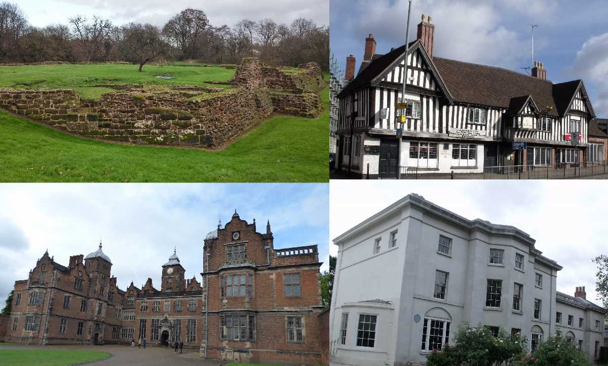
Roman Birmingham at Metchley Roman Fort, AD 48
Although there is nothing to see above the ground, between the Queen Elizabeth Hospital Birmingham and the University of Birmingham in Edgbaston, it was discovered that the Romans had built a fort here called Metchley Fort. It was on the Roman road Icknield Street. The fort was built a few years after the Roman invasion of Britain in AD 43. The fort was built in AD 48 and was made of timber. The fort was abandoned in AD 70, only to be reoccupied a few years later before being abandoned again in AD 120. The remains were first discovered in the 18th century. Further excavations took place in the 1930s, '40s, '50s and '60s. The most recent excavations took place in the 2000s.
dndimg alt="Metchley Roman Fort" dndsrc="../uploadedfiles/Metchley Roman Fort (3).jpg" style="width: 100%;" />
For more on Metchley Roman Fort have a look at this post: Metchley Roman Fort between the University of Birmingham and the QEHB .
Beorma Ingas ham, 7th century
This sculpture is located on a bridge over the River Rea on Gooch Street in Highgate. The Beorma was the name given to a 7th century Anglo-Saxon tribe who settled in the future Birmingham area, on a site around the River Rea in what is now part of Highgate. This was before the first mention of Birmingham in the Domesday Book in 1086 by the Normans. They were an ancient Anglian tribe. Beorma Ingas ham means The home of the people of Beorma. And early origin name for what later became Birmingham. This tribe pre-dates the Anglo-Saxon Kingdom of Mercia, which later had their capital at Tamworth. Throughout history there has been many different ways of spelling Birmingham (starting with Bearm, Berm, Beor, Bearma, Beorm and Breme). Think of Bromwicham, or Brumwicham. The nickname now for the people of Birmingham is Brummies! Beorma also gave their name to West Bromwich, Castle Bromwich, Bromsgrove and other local places in the Midlands. The sculpture was made in 2002 (or 2006). Beorma gives their name to the Beorma Quarter development in Digbeth.
dndimg alt="Beorma" dndsrc="../uploadedfiles/Beorma Ingas Ham Gooch St Highgate (March 2013).JPG" style="width: 100%;" />
dndimg alt="Beorma " dndsrc="../uploadedfiles/Beorma Ingas Ham Gooch St Highgate (March 2013) Rea.JPG" style="width: 100%;" />
Peter de Birmingham, Lord of the Manor of Birmingham in 1166
In 1166, the Lord of the Manor, Peter de Birmingham got a Charter to hold a market from the King (Henry II). He lived in a moated manor house (which today would be on the Smithfield site). His market would become the Bull Ring which is still trading after 850 years. The market was so successful, that it led to his town of Birmingham expanding. That meant some of the land that was the deer park could be built on.
dndimg alt="Peter de Birmingham" dndsrc="../uploadedfiles/Peter de Birmingham 1166 (1).JPG" style="width: 100%;" />
Weoley Castle built after 1264
These ruins are of Weoley Castle. Grade II listed and a Scheduled Ancient Monument. It is thought to date to about 1264 and built for Roger de Somery who was licenced to crenellate his manor house. He was probably the Lord of the Manor of Dudley, who was given permission by the King (Henry III) to build and fortify his castle in stone. In the Middle Ages the castle was at the heart of a large deer park covering nearly 1000 acres. The estate was bought by the Birmingham Corporation in the 1930s. And is now one of the properties of the Birmingham Museums Trust.
dndimg alt="Weoley Castle" dndsrc="../uploadedfiles/Weoley Castle Ruins (Dec 2015).jpg" style="width: 100%;" />
I'll expand a post on the Weoley Castle ruins soon.
William de Birmingham, Lord of the Manor in 1300
In this Moated Manor House around the year 1300 lived the Lord of the Manor, William de Birmingham. In the years since his ancestor Peter got a Charter for a market, it had been very successful and the town was growing. Not far from the moat was St Martin's Church. As early as the year 1300, the roads Edgbaston Street, New Street and Park Street existed. But William still had deer park surrounding his town. He taxed the inhabitants of the town, but later allowed houses to be built on parts of his deer park (there used to be a ditch near Park Street separating the town from the deer park). The moat was filled in by the 19th Century to make way for the Smithfield market (later the site of the Birmingham Wholesale Market and future Smithfield redevelopment site). This model is in the Birmingham History Galleries at the Birmingham Museum & Art Gallery.
dndimg alt="Birmingham 1300" dndsrc="../uploadedfiles/Birmingham in 1300 (3).JPG" style="width: 100%;" />
For more of 1086 to 1300 check out this post for more details: Birmingham from the Domesday Book in 1086 to 1300 when William de Birmingham was Lord of the Manor.
The Old Crown, Digbeth 1368
This old pub in Digbeth, claims to be one of the oldest surviving buildings in Birmingham. The Old Crown claims to date to the year 1368, although most of the timber framed building today probably dates to the 16th century. It is believed that the building was built between 1450 and 1500 with some evidence suggesting 1492. It is a Grade II* listed building. It was originally built as the Guildhall and School of St. John, Deritend. It might have first gained the name 'The Crown' in the late 16th century after the failed Armada invasion. Evidence shows that it was first used as an in during the early 17th century, around 1626. It was converted into houses in the late 17th century. The pub was saved in the mid 19th century from demolition. In the late 20th century and into the 21st the pub has had several restorations by the present owners.
dndimg alt="The Old Crown" dndsrc="../uploadedfiles/The Old Crown 1368 (Oct 2009).JPG" style="width: 100%;" />
Tudor Merchant's House, Kings Norton 1492
Probably the oldest building in Kings Norton is the Tudor Merchant's House, later known as the Saracen's Head. A Grade II* listed building. The house was built in 1492 by a wealthy merchant, Humphrey Rotsey (it is now the north range). The house faces the Church of St Nicholas. The range of buildings were expanded by 1510. In 1643 Queen Henrietta Maria of France stopped here on the way to join King Charles I at his headquarters in York. It had become a pub by the 18th century. Another wing was added in the 19th century. In 2004 it won the BBC's Restoration programme along with The Old Grammar School and both were fully restored and reopened by 2008 under the name of St Nicolas Place.
dndimg alt="The Saracens Head" dndsrc="../uploadedfiles/Saracens Head Saint Nicholas Place Kings Norton (4).JPG" style="width: 100%;" />
For more on Kings Norton follow the link to this post: Kings Norton around The Green including Saint Nicholas Place.
Blakesley Hall, Yardley 1590
This tudor hall was built in 1590 for Richard Smalbroke. Blakesley Hall is one of the oldest buildings in Birmingham. At the time Yardley was in Worcestershire and the timber-framed farmhouse was built for Smalbroke's farm. Many other buildings followed over the years. After 1685 the farmhouse passed to the Greswolde family and was a tenant farm for the next 200 years. Henry Donne acquired the hall in 1899. The hall became a museum after 1935. It is now a Grade II* listed building and is run by the Birmingham Museums Trust.
dndimg alt="Blakesley Hall" dndsrc="../uploadedfiles/Blakesley Hall (Jan 2010).jpg" style="width: 100%;" />
For more of Old Yardley check out this post about the nearby village: Old Yardley Village: a hidden gem not far from Blakesley Hall. I will have to do a detailed Blakesley Hall post soon.
Stratford House, Highgate 1601
Seen from the Moseley Road in Highgate (in front of the modern Highgate Middleway) is Stratford House. A Grade II* listed building. It was built in 1601 for Ambrose Rotton and his wife Bridget. It has survived over 400 years despite recent fires. There had been lead light replacements in the 18th century. Had internal alterations in the 1820s to 1830s. There was a restoration in the 1950s. In recent years it's been either offices or a night club, or just been vacant. There was a fire here in the mid 2010s, but that damage has since been restored.
dndimg alt="Stratford House" dndsrc="../uploadedfiles/Stratford House (April 2018).jpg" style="width: 100%;" />
Aston Hall in Aston Park 1635
Aston Hall was built between 1618 and 1635 for Sir Thomas Holte (who moved in 1631). It was a leading example of a Jacobean house. The house is a Grade I listed building. It was built within a large parkland which included the land where Villa Park, home of Aston Villa is now. The remaining park now surrounding the hall is Aston Park. The house was severely damaged in 1643 when it was attacked by Parliamentary troops during the English Civil War. The house remained in the Holte family until 1817 when it was leased to James Watt Jr.. In 1858 the house was purchased by a private company who used the hall as a museum. It was later bought by the Birmingham Corporation (later Birmingham City Council) in 1864 becoming the first historic house to pass into municipal ownership. The Birmingham Museums Trust took over the running of the hall from the Council in 2012.
dndimg alt="Aston Hall" dndsrc="../uploadedfiles/Aston Hall (September 2017).jpg" style="width: 100%;" />
For my post on Aston Hall and Aston Park follow this link: Aston Hall and Park in autumn and winter. I've prepared another Aston Hall post (coming soon), where you can see what it looks like fromt the inside.
Soho House, Handsworth 1766
The home of Matthew Boulton, one of the members of The Lunar Society and business partner to James Watt, was his home from 1766 until his death in 1809. Soho House is a Grade II* listed building and now run as a museum by the Birmingham Museums Trust. Samuel Wyatt in 1789 and James Wyatt in 1796 built extensions to the house. After Boulton's death, it was inherited by his son in 1809 and his grandson who later sold it in 1850. It then had numerous owners and uses including as a hostel for police officers. Birmingham City Council acquired in in 1990 and turned it into a museum in 1995. The Lunar Society met here when their was a full moon, and their discussions contributed to the Industrial Revolution.
dndimg alt="Soho House" dndsrc="../uploadedfiles/Soho House (July 2010).JPG" style="width: 100%;" />
Soho House is covered slightly in this post along with Stratford House and Selly Manor: A selection of Birmingham's great Manor Houses. I have prepared a Soho House post and you can see it soon.
Sarehole Mill 1771
There has been a mill on a site in the Sarehole area of what is now part of Moseley (near the Hall Green border) since about 1542. Sarehole Mill is near the River Cole, and was used to grind corn. Previously it was known as Bedell's or Biddle's Mill. By 1727 it was known as High Wheel Mill. Matthew Boulton leased the previous mill on this site in 1755 for use for metal working. The current building was built in 1771 and was used until 1919. It is known for it's association with J. R. R. Tolkien who lived nearby in the area as a child on Wake Green Road (from 1896 to 1900). These days the mill is a museum, having been restored in 1969. Another more recent restoration was in 2012-13. The Bakehouse was restored early in 2020, and during the lockdown they have opened up a shop selling food such as bread, pastries, pasta, flour and other items. Nearby is the Shire Country Park with various satellite parks (such as Moseley Bog), good for walks.
dndimg alt="Sarehole Mill" dndsrc="../uploadedfiles/Sarehole Mill open day (Oct 2013) (5).JPG" style="width: 100%;" />
For my recent post on J. R. R. Tolkien in Sarehole, featuring the mill, have a look at my post here: J. R. R. Tolkien in Sarehole from 1896 - 1900.
Birmingham Council House, Victoria Square 1879
The Council House was built from 1874 to 1879 from designs by Yeoville Thomason. The first stone was laid by the then Mayor of Birmingham Joseph Chamberlain. The clock tower behind is known as Big Brum. The Council House was expanded in 1881-85 again by Yeoville Thomason. Birmingham gained City Status from Queen Victoria in 1889. The second extension was built from 1911 to 1919 (by architects Ashley & Newman). Both buildings includes the Birmingham Museum & Art Gallery on the upper floors. They are a Grade II* building. In 2019, Birmingham celebrated it's 130th birthday as a City, but as you can see above, our history goes much further back.
dndimg alt="Birmingham Council House" dndsrc="../uploadedfiles/Brum130 Council House Victoria Square (7) .jpg" style="width: 100%;" />
For my Council House post follow this link: Birmingham Council House - the seat of local Government in Birmingham.
Photos taken by Elliott Brown.
Follow me on Twitter here ellrbrown. Now at more than 1,130 followers. Thank you.
Birmingham We Are People with Passion award winner 2020
.JPG?v=1)
.JPG)